 APPALACHIAN TRAIL| Take a Walk on the Wild Side| Nantahala| Tellico Gap to Wayah Bald
Article & Photography by Mina Thevenin
August 2015
On the Appalachian Trail, do you know the way? The way to Wayah Bald, North Carolina by the A.T. of Tellico Gap?
Invited by two “section hikers” to join them on a short leg of their long-term quest to hike the nearly 2,200 mile long Appalachian Trail, I gratefully accepted: hiking the Appalachian Trail in Nantahala National Forest from Tellico Gap to Wayah Bald. What better opportunity for the Photography World Appalachian Trail hike article, than to hike with experienced and knowledgeable A.T. hikers, both of whom were agreeable to accommodate my frequent photography stops and conversations along the way, even all the way to Wayah!
What’s the difference between a gap and a bald, at least the difference between the Appalachian Trail Tellico Gap trailhead and Wayah Bald stone observation tower?

Oh, about 9.2 miles and a North to South elevation of about 1,200 feet of moderate trail ascent. (1)
Click on any image to view photography gallery as a slideshow. Scroll over image with mouse for copyright detail.
GAP A Gap is a low geographic region nestled between two higher elevation peaks. A mountain gap or pass allows travelers an easier access route.
BALD A Bald is a treeless flat area on a knob or mountain with shrub-dominated areas or tundra-like grasslands at the highest summits with spruce-fir forests (2). Wayah Bald has an elevation of 5,342 feet (1628.24 m), is accessible by car and a short walk, or by hiking on the Appalachian Trail. Early 20th century Wilson Lick forest rangers from 1916 through the mid twentieth century issued grazing permits for cattle that roamed the mountain. These free-range cattle once helped to keep the bald free from trees, though Wayah Bald now relies on occasional maintenance and pruning by the Forest Service.

Wa-ya means wolf, as defined by the Manataka American Indian Council, a non-profit organization that promotes American Indian history and culture. Wayah (Bald) derives its name from this Cherokee Indian word.
Ongoing preservation of the historic Wayah Bald allows for visitors to enjoy the breathtaking mid-June showcase of the surrounding natural azalea thicket beyond the stone observation tower. When the area is in full bloom it provides a dazzling showcase of pink, white and orange blossoms. But even when visiting the Wayah Bald in mid-August, as I did, the four state view from the tower was incredible! On a clear day one can see the Appalachian Mountains in Georgia, Tennessee, North Carolina and South Carolina. (Image above is the view from Wayah Bald stone tower, looking toward the Appalachian Mountains of North Carolina and the Smoky Mountains of Tennessee.)
BLAZING THE APPALACHIAN TRAIL

The Appalachian Trail itself is trail-marked with the white A.T. blaze; usually found on trees, the white paint strip measures two inches wide and six inches high. Camp sights and shelters are indicated by the blue blaze. There are also other colored blazes used that represent intersecting trails to the A.T.
The Appalachian Trail Conservancy is a non-profit organization that serves to preserve and manage the Appalachian Trail. Through the spirit of cooperation with volunteerism and community support, the ATC serves to sustain, educate and protect the A.T., “ensuring that its vast natural beauty and priceless cultural heritage can be shared and enjoyed today, tomorrow, and for centuries to come.” (3)


 APPALACHIAN TRAIL Flora in August
An interesting plant growing alongside the trail was the lacy and delicate orange, or yellow-fringed orchid (image left). Blooming in a patch of three plants, the orchid grew from the ground and stood approximately a foot from the soil. Elevation was roughly under 4,800 feet. These plants were in the shade of tree canopy with a fairly moist ground. Temperature was roughly in the upper 60’s Fahrenheit.


Carolina Phlox also bloomed in small patches along the trail this August. Shown here in a purple-blue is the bud detail, a mature plant already flowering.
Because of the higher altitude’s moist and cool environment, the greens of summer were still green in August and there were quite a number of colorful plants to enjoy. Even the cheery yellow aster, with curly stigma peppered the sides of the A.T. (bottom left). Seed-developing stalks of the tall Black Cohosh were seen, along with end of season spotted-winter green (Pipsissewa is its Cherokee name.)
Lower altitudes along a Nantahala Lake stream get enough sunshine that common Joe Pye Weed was flowering. Tall blooming stalks of pink and purple Ironweed and fields of yellow Aster color the fields. In the late day sunny pass of Tellico Gap, though sheltered from direct sunlight, bloomed yellow and orange Jewelweed this August. Pokeweed also bloomed in Tellico Gap.
Weeds, as they are commonly called, are wildflowers- many of which hold medicinal properties used for centuries by Native Americans and mountain people. Continuing to be a stronghold of interest, even today people utilize homeopathic remedies, from which western medicine has removed itself long ago.

NANTAHALA MOUNTAINS AND A RHYTHM OF FOG


SLEEPING WITH MICE on the Appalachian Trail
“You didn’t read up on sleeping in the A.T. shelters yet, did you?” Doug Meyer asked me. Meyer, who had just returned from his work in Denmark’s 2015 European StoneAge Festival, is an American Primitive Technologist. Meyer’s companion hiker for the Appalachian Trail is Chris Proctor, an avid hiker and martial arts enthusiast. (Meyer and Proctor are also cousins.) They were my A.T. Photography World team.

Many of the shelters along the A.T. have an unfortunate issue with little visitors: mice. Along the Tellico Gap to Wayah Bald, we stayed over night at the highest shelter (nearly 5000 feet) on the Nantahala’s Ridge, the Cold Spring Shelter. We shared the three-sided shelter with a Maryland father-son team who were wrapping up their section hiking (this was their third section hike of the past five years), and who unfortunately had a painful case of trench foot because three of their five days involved hiking in the rain. We shared camaraderie and good cheer at my expense, as the mice abandoned everyone else and chattered their squeaks while pilfering the hat around my head as I slept. Taking one for the team, I was glad to be such a distraction for Meyer, Proctor, and the trench foot boys. Thanks guys.
Whether hiking back country on a long thru, section hiking, or hiking as a day-tripper, hiking 101 research recommends doing the research. Read up on hiking/backpacking. Use maps. Know what basic gear is essential- first aid, food, water. Do you use poles? Knowing that a cell phone does not always get reception in the mountains and what about recharging the phone?
INTERVIEW with Appalachian Trail section hiker and expert outdoors-man, Doug Meyer:
People learn really quickly what they need to pack and what they don’t need. I try to carry gear that I can use for multiple purposes. For example, rain gear- you’re out sweating on the trail anyway, so in warm weather some rain will feel good. But if it pours down rain I’m going to hold up somewhere; I’m not going to walk out in it. Dry wick shirts are good. Don’t wear jeans and t-shirts. Cotton is horrible for hikers. A hiker wants to wear something that will dry quickly and keep the moisture away from the body..
Q: As an expert hiker, what would you recommend is needed for a day hike versus trekking in for one or two nights of camping?![]()
MEYER: Even for a day hike you want to have minimal gear, just in case you have to hold up some where: a space blanket and matches. The blanket can be used to wrap around you if you need to make a fire and the reflective side will create more warmth. Particularly on a day hike take a snack and water. Going out for several days: sleeping bag, hammock, extra food, water and ways to purify water. First aid kit. Map. Weather can change really quickly and loss of light early can be challenging. Appalachian trail hiking can be pretty intense.

Though we only hiked under 10 miles, there was an impression of what the thru-hikers and section hikers might experience on their 2,200 mile journey. The goals and determination one must have to hike the A.T.- such a vast distance that encompasses 14 states of the United States’ most eastern mountain range with the terrain varying geographically. All is effected by weather. All is effected by, at least at times, constraints of time in such a timeless place…getting in the miles to make it to the next shelter or to the section hike pick-up point on your route. Watching for the white blaze or cairn (pile of stones) to show the way, the route….
NORTHBOUND VS. SOUTHBOUND ROUTE
The southbound thru-hike is Maine to Georgia. The A.T.’s northern terminus begins in Maine’s Baxter State Park at Mt Katahdin; this is to be the most difficult starting point because of the rugged terrain (advised only for the most experienced hikers). Consequently, the Northbound start of Georgia’s Springer Mountain is more popular than beginning at Maine’s Mt Katahdin for this reason.
Starting in the south and working northward (Northbound) is the more popular route.
Beginning in the southern state of Georgia, the A.T. (Appalachian Trail) trailhead begins (or ends) at Springer Mountain, Chattahoochee National Forest of the Blue Ridge Mountains. It follows the up and down spine of the mountains into North Carolina’s Wayah Bald of the Nantahala National Forest and Tennessee’s Smoky Mountains. It is along the Tennessee/North Carolina A.T. crestline that the trail of this region’s coniferous rainforest reaches an elevation of 6,643 feet near the summit of Clingmans Dome, an A.T.’s high point, but it is North Carolina’s Mount Mitchell that claims the A.T.’s highest peak at 6,684 feet. Northward into Tennessee the A.T.’s Little Rock Knob of Roan Mountain is part of the southern Appalachian highlands and it boasts the highest elevation shelter, Roan High Knob, available to hikers- 15 hikers can utilize the two-story log cabin rebuilt in 1988 from its original 1933 construction, but a reservation must be made in advance. (Tennessee has more specific laws requiring permits and registrations; to check out all that is required on the A.T., click the Appalachian Trail Conservancy Regulations & Permits regarding different A.T. states, and whether or not you are a thru-hiker, backcountry camping, etc.) When shelters undergo renovation- they are closed for use. The Cold Spring Shelter we used just a couple of weeks ago, is currently closed for renovation. It is very important to check the latest closings and re-routes of the trail before going.
Northbound thru-hike is the route from Georgia to Maine, though starting in March or April in the highlands, one will encounter winter weather conditions similar to the New England states. (Above information as referenced from the ATC website.)
If you have the time and are planning to “thru-hike” the Appalachian Trail, completing it within one year, then you may be interested in registering: Appalachian Trail Thru-Hiker Voluntary Registration. Why? Registering your thru-hike helps to decrease the ecological impact of long term hikers by their footprint of overcrowding.
According to the Appalachian Trail Conservancy(4):
WHAT’S THE BEST TIME TO START A THRU-HIKE OF THE ENTIRE A.T.?
There’s no single “best” time to start. What’s best for you will depend on:
– your tolerance and preparedness for extreme cold and snow
– whether you enjoy solitude or crowds
– your backpacking experience
– your fitness level
– your pace and the time period you can allot to the hike
Thru-hikers have the opportunity to experience a realization of one’s own, that sense of self away from the hustle of work-a-day world and often over-dependency on material things. The A.T. thru-hiker connects with nature and connects with self, eventually maybe even leaving self behind through this journey.
Hiking the A.T. in general offers camaraderie among its people. On the trail it doesn’t matter what line of work one does and there’s an obvious communion of everyone being on equal ground. Fellowship. Common goals of hiking- safety, shelter, food and water, and when camping- swapping stories, however brief or long. The sharing of hello’s, nods of the head, and acknowledging, “it’s beautiful.”
Since most people don’t have the time for thru-hiking, maybe breaking the current 2015 ATC report of 2,189.2 miles/3523.18 km into two to three big segments is doable. If so, then one might be interested in the Alternative Thru-Hike, aka “flip-flop thru-hike”, when people can choose to hike during more favorable weather, i.e. spring, summer and fall. South of the Shenandoah River is Harpers Ferry, West Virginia, (home of the Appalachian Trail Conservancy’s headquarters and visitor center); this is often a starting place for the Alternative thru-hike.
UTOPIAN WILDERNESS
Visionary Harvard graduate Benton MacKaye (pronounced MaKee), the brain of the A.T., proposed a Utopian wilderness in 1921 to break from the stress of modern living and by connecting with nature, renew the person. Capitalizing on numerous Appalachian trails already created by various trail clubs, such as the Appalachian Mountain Club in New Hampshire’s White Mountains and the Green Mountain Club in Vermont, MacKaye envisioned a recreational long trail along the Appalachian Mountain skyline stretching from North to South that would connect various “camps” for residents and travelers. These camps would be self-sustaining, worked by residents and the vacationing passers-thru who could volunteer their efforts while benefiting from outdoor living. This proposal was published in the October 1921 Journal of the American Institute of Architects. (5).
In his article, “An Appalachian Trail: A Project in Regional Planning”, MacKaye proposed:
As far as possible the blazing and constructing of the trail and building of camps should be done by volunteer workers. For volunteer “work” is really “play.” The spirit of cooperation, as usual in such enterprises, should be stimulated throughout. The enterprise should, of course, be conducted without profit. The trail must be well guarded — against the yegg-man and against the profiteer.
Arthur Perkins picked up the trail proposal in 1926 and in 1927 enlisted the A.T. trail’s architect, Myron Avery. Avery organized new trail clubs and encouraged already established trail clubs to pursue MacKaye’s original goals for the estimated 2,000 mile trail (the length of the trail varies as trails are re-routed over time) that today reaches into 14 states (Maine, New Hampshire, Vermont, Massachusetts, Connecticut, New York, New Jersey, Pennsylvania, Maryland, West Virginia, Virginia, Tennessee, North Carolina, and Georgia), eight national forests, and six units of the national park system.
The Appalachian National Scenic Trail
To protect national trail systems from groups benefiting from financial recreational opportunities and threats from commercial development, Congress passed the 1968 National Trails System Act, P.L. 90-543, which became law on October 2, 1968 . The Appalachian National Scenic Trail was the first trail to fall under this new act. The year 2018 marks the 50th year anniversary of the NTS. According to an NTS overview article By Sandra L. Johnson, Technical Informantion Specialist
The Act established the Appalachian and Pacific Crest National Scenic Trails and authorized a national system of trails to provide additional outdoor recreation opportunities and to promote the preservation of access to the outdoor areas and historic resources of the nation. The National Trails System includes four classes of trails:
- National Scenic Trails (NST) provide outdoor recreation and the conservation and enjoyment of significant scenic, historic, natural, or cultural qualities;
- National Historic Trails (NHT) follow travel routes of national historic significance;
- National Recreation Trails (NRT) are in, or reasonably accessible to, urban areas on federal, state, or private lands; and
- Connecting or Side Trails provide access to or among the other classes of trails.
Johnson’s article cites the current 2015 National Trail Systems to include the following 20 federal components:
| Year | Trail | Public Law |
| 1968 | Appalachian NST | P.L. 90-543 |
| 1968 | Pacific Crest NST | P.L. 90-543 |
| 1978 | Continental Divide NST | P.L. 95-625 |
| 1978 | Oregon NHT | P.L. 95-625 |
| 1978 | Mormon Pioneer NHT | P.L. 95-625 |
| 1978 | Iditarod NHT | P.L. 95-625 |
| 1978 | Lewis and Clark NHT | P.L. 95-625 |
| 1980 | North Country NST | P.L. 96-199 |
| 1980 | Overmountain Victory NHT | P.L. 96-344 |
| 1980 | Ice Age NST | P.L. 96-370 |
| 1983 | Florida NST | P.L. 98-11 |
| 1983 | Potomac Heritage NST | P.L. 98-11 |
| 1983 | Natchez Trace NST | P.L. 98-11 |
| 1986 | Nez Perce (Nee-Me-Poo) NHT | P.L. 99-445 |
| 1987 | Santa Fe NHT | P.L. 100-35 |
| 1987 | Trail of Tears NHT | P.L. 100-192 |
| 1990 | Juan Bautistade Anza NHT | P.L. 101-365 |
| 1992 | California NHT | P.L. 102-328 |
| 1992 | Pony Express NHT | P.L. 102-328 |
| 1996 | Selma to Montgomery NHT | P.L. 104-333 |
APPALACHIAN MOUNTAIN RANGE SPANS 14 STATES ON THE A.T.
- Black Mountains of Georgia & North Carolina
- Cumberland Mts. in Tennessee
- Blue Ridge Mts. in Virginia
- Alleghenies of Virginia, West Virginia, Maryland & Pennsylvania
- Kittatinny Range of New Jersey
- The Taconics of Connecticut
- The Berkshires of Massachusetts
- The Catskills Mts. in New York
- The Green Mts. in Vermont
- White Mts. of New Hampshire
- Mahoosuc Range of Maine is the Northern Extension of the White Mts

Disclaimer: This PHOTOGRAPHY WORLD article is not intended to represent expert advise on hiking the Appalachian Trail. Our intention is to promote and excite hikers to get out and explore our great American landscape by sharing a photographic journey and article information as research gleaned from a plethora of expert books and websites on Appalachian Trail hiking. Hiking any portion of the A.T. requires research and preparation as trail conditions change frequently. In addition to proper gear, planning for physical and mental readiness- primarily for safety reasons, will lend to a hiker’s overall A.T. experience as not only memorable and successful, but also life-changing!
Change your life today. Do you have a local hiking club? Get involved! Hike & volunteer today. LEAVE NO TRACE(TM)!
.
.
.
COWEE MOUNTAIN tops jut through the sunrise mist as A.T. hiker Chris Proctor stands on an outcropping of boulders overlooking sunrise that covers just east of the Little Tennessee River Valley. Cover image for APPALACHIAN TRAIL| Take A Walk on the Wild Side| Nantahala
Tellico Gap to Wayah Bald
Article & Photography by Mina Thevenin
*****
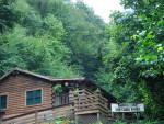
Nantahala Log Cabin Lodge
If you go to Nantahala National Forest and wonder where to stay, Photography World found Nantahala Log Cabin Lodge tucked off the road. Cindy and the Johnson’s welcome guests to sit a spell on a long covered porch with rockers & hummingbird feeders. Hot showers. Nice folks. (Be sure to mention Photography World & Cindy said she’d give 10% off your stay.) 706-589-6438
 Nantahala Log Cabin Lodge
14565 Hwy 19 W
Bryson City, NC 28713
Open April 1st – October 31st
In addition to the cited end notes, this Photography World article cross-referenced resource information from the following sources:
Lisa Williams (Georgia), Richard H. Ketelle (Smokies), Don O’Neal (North Carolina) Editors, Appalachian Trail Guide to North Carolina-Georgia, including the Great Smoky Mountains National Park, (Appalachian Trail Conservancy, Harpers Ferry, WV: USA, 14th Edition, 2011)
Victoria and Frank Logue with Leonard M. Adkins, the best of the APPALACHIAN trail, OVERNIGHT HIKES, 2nd ed., (ATC, Harpers Ferry WV: Menasha Ridge Press, 1994, 2004)
(1) Doris Gove, Exploring the APPALACHIAN TRAIL: Hikes in the Southern Appalachians, Georgia, North Carolina, Tennessee (Mechanicsburg, PA: Stackpole Books, 1998) 110.
(2) “Wayah Bald”. Blue Ridge National Heritage Area. WEBSITE
(3) Appalachian Trail Conservancy. WEBSITE
(4) Ibid.
(5) MacKaye, Benton. “An Appalachian Trail: A Project in Regional Planning.” Journal of the American Institute of Architects. (October 1921): http://users.fred.net/kathy//at/mackaye.html. WEB. 29 August 2015.
About the Author
Mina Thevenin is a photographer, writer, and editor for Photography World, Ltd Co. She is interested in working on stories that spark awareness of a growing social consciousness & responsibility for a positive today and tomorrow.
.
To contact her: leave a comment with a valid email below. She attempts to respond to most all comments & questions about Photography World and www.photographyworld.org. Article ideas are welcome.

Great read! Thanks & wanna see those types of views when I go!